Cape St George and Long Nose (Jervis Bay)
Grade 4: Important as a scenic area where both Cook Landmarks are incorrectly placed on today’s maps and charts. Steamers Head (Cook’s Cape St George) is a dramatic feature, being the highest sea cliff in New South Wales. Point Perpendicular (Cook’s Long Nose) gives expansive views south across Jervis Bay, west to Longnose Point, and south west to Pigeon House.
Situation: Approximately 30km NE of Nowra, New South Wales. Point Perpendicular (Cook’s Long Nose) is located in the Department of Defence Beecroft Weapons Range and only accessible at certain times. Details: http://www.pointperp.com/PDF/Welcome_to_Beecroft_Weapons_Range.pdf
Today’s Cape St George and Steamers Head (Cook’s Cape St George) are located in Booderee National Park, see: https://parksaustralia.gov.au/booderee/plan/maps-apps/. Today’s Cape St George (not to be confused with Cape St George lighthouse) can be viewed to the south from near Stony Creek car park. Steamers Head can be viewed from Brooks Lookout, accessed by walking from the car park located to the south of Stony Creek Road. There is no formed access to Steamers Head itself.
Coordinates (decimal):
Today’s Cape St George: 35.17 S 150.76 E, no coordinates given for Steamers Head, Cook’s Cape St George.
Today’s Longnose Point: 35.08' S 150.77' E
Point Perpendicular (Cook’s Long Nose): 35.10 S 150.80 E
Endeavour Journal, 24 April 1770:
Stood to the NE until noon… at which time we tacked and stood to the westward being by obsern in the Latde of 35.10 S and Longde 208.51 W. A point of land which I named Cape St George we having discover’d it on that saints day, bore West distant 19 miles…
About 2 Leagues to the northward of Cape St George the Shore seems to form a bay which appeard to be shelterd from the NE winds but as we had the wind it was not in my power to look into it and the appearance was not favourable enough to induce me to loose time in beating up to it. The north point of this bay I have named Long Nose Latitude 35.4 S…
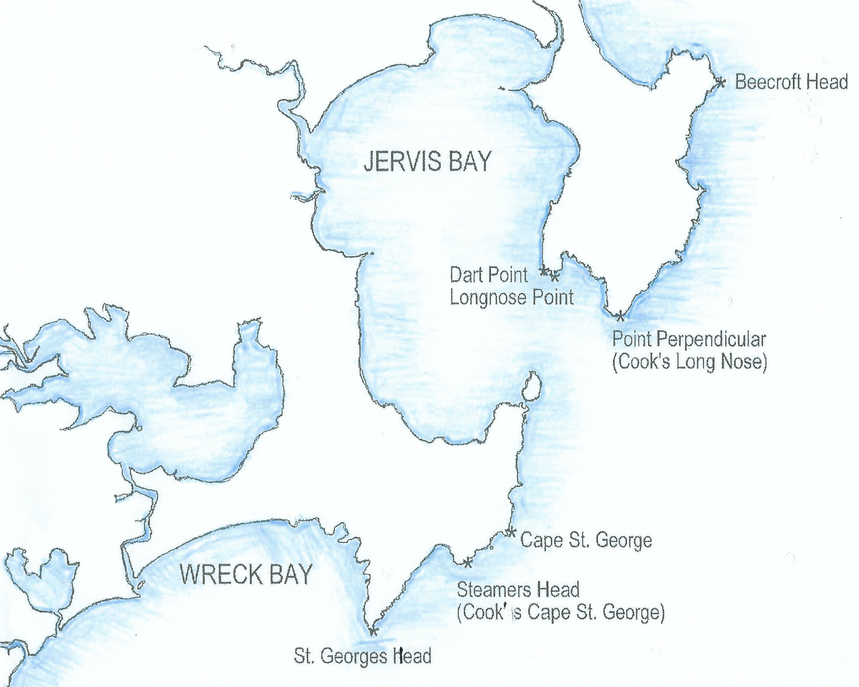
Both of these features are at Jervis Bay, south of Wollongong, New South Wales.
Cape St George:
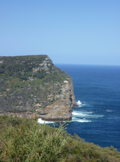
Today’s Cape St George, to the south of the entrance to Jervis Bay, is at much the same latitude at Cook places it, 35.10 S. It is a low grassy point about 40 metres above the sea. Cook puts it at 19 nautical miles due west of his noon position on 24 April 1770 which was 35.10 S. However from Cook’s position this cape would barely have been visible because of the curvature of the earth. So what did Cook see and name? There seems little doubt that Cook named a prominent feature marked on today’s maps as Steamers Head. This lies about two kilometres south west of today’s Cape St George. A high and distinctive cliff with a sheer golden sandstone face, it would have stood out as a feature on this otherwise relatively low lying coast where trees and scrub run down to the shore. Indeed this is the highest sea cliff on the New South Wales coast at 135m, and far higher than the coast to either side of it. From 19 miles out to sea it would appear as a 100m cliff.
Early explorer George Bass, to his credit, was the first to record that today’s Steamers Head was Cook’s Cape St George, though he did not realise this until he returned from his 1798 voyage:
…at about the distance to the southward of Jervis Bay which Capt. Cook fixes his Cape George, there is a high mountainous point or cape that forms the northern extreme of the bight at the back of which the Pidgeon House is situated. About 2 miles to the southward of this cape I had an observation which gave latitude 35.14, but I then had no idea of its being Cape George…
This describes Steamers Head in terms of both its physical appearance and its position on the coast. Bass’s observed latitude is not two but about three and a half nautical miles south of Steamers Head. Bass’s latitudes are understandably approximate as his observations were taken from a small pitching vessel, and his estimation of the distance is a qualified one. Unfortunately Bass’s placement of Cape St George at Steamers Head has never influenced maps or charts.
Long Nose:
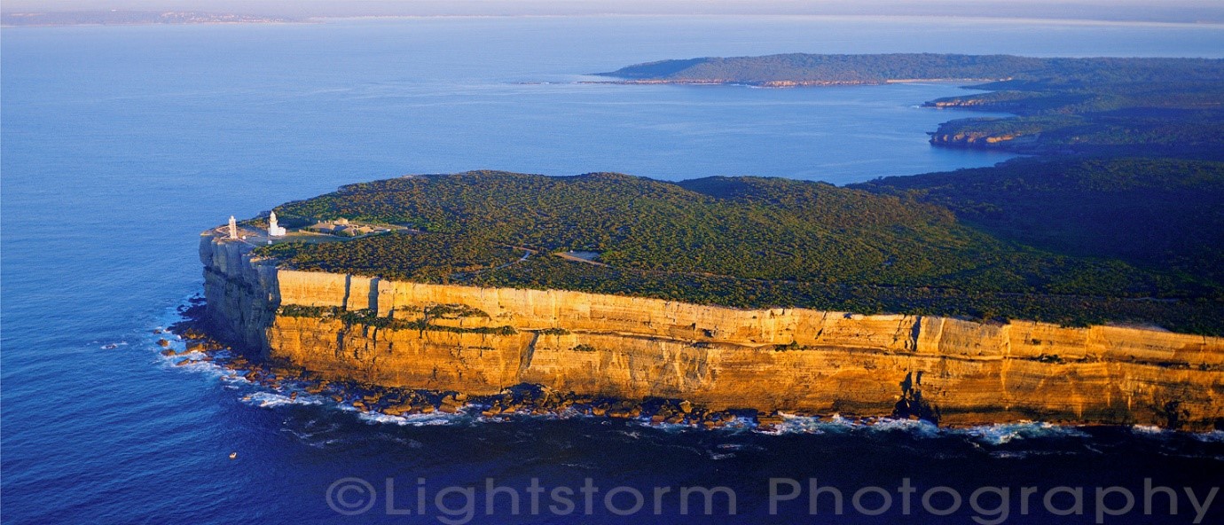
The most distinctive feature of the entrance to Jervis Bay is the northern head, a long and sheer cliff face more than 80m high meeting the bay at today’s Point Perpendicular. Cook’s chart and journal show that he was three or four leagues offshore, between 16 and 22 km, when he named this land feature. From that distance he would have been able to clearly see Point Perpendicular but not today’s Longnose Point, a low peninsula about three kilometres to its north west. Point Perpendicular and the cliffs to its north is what Cook saw and aptly named as Long Nose. Following his whaleboat voyage along this coast in 1797-8 George Bass decided that today’s Longnose Point, inside today’s Point Perpendicular, was the Long Nose of James Cook. Bass’s Longnose Point is indeed a point but it is very low lying and could not have been seen from Cook from his position far out to sea. Bass’s error was perpetuated on Admiralty charts by Flinders. and Stokes and has appeared on charts to this day.
References:
Trevor Lipscombe, 'Jervis Bay - what Lt James Cook really named', Placenames Australia, June 2017. 'James Cook at Jervis Bay - How the chart makers got it wrong', Map Matters, Issue 30, February 2017. ‘Where are Cook’s Cape St George and Long Nose?’, Cook’s Log, Vol 41 No 2, April-June 2018. https://www.captaincooksociety.com/home/detail/where-are-cook-s-cape-st-george-and-long-nose